
Our work with councils, supporting them to deliver successful School Streets, varies from place to place.
Here is a look at our analysis of Havering School Streets.
Complementary measures analysis for Havering School Streets
Havering Council commissioned the team at MP Smarter Travel to carry out feasibility studies for 12 School Street sites across the borough.
The studies aimed to identify complementary measures that would support the School Street objectives and improve students’ journeys to school.
Or team worked alongside highway engineering and planning consultancy, City Infinity, conducting stakeholder engagement and site visits to identify three to five priority engineering interventions for each location.
The interventions were designed to enhance safety, encourage walking, wheeling and cycling and reduce congestion around schools.
Project outcomes
- 12 site visits
- 12 school meetings held
- 70 recommendations given
- 82 safe crossing points mapped
In-depth school meetings
Each school was able to share direct feedback based on their observations, highlighting both concerns and improvements resulting from the School Streets.
Site visits
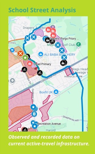
Our team conducted site visits during peak pick-up and drop-off hours to audit and assess the different School Streets. We reported observations on traffic, parking, driving behaviours, active travel and the main desire lines.
Site mapping
We used Geographic Information Systems (GIS) to create site maps of each site to show current infrastructure and recommended measures to support the student journey to school.
Recommendations
Examples of our engineering recommendations for improving each site, based on the stakeholder feedback and site visits, were as follows:
- Introduce safe crossing points
- Behaviour change engagement and measures
- Re-design road layouts
Get in touch
If you would like extra resource to deliver well-informed School Streets in your borough, email us: info@mpsmartertravel.co.uk