
We have worked with councils and schools delivering many School Streets over the years across a number of diverse locations.
Here is an overview of the work we completed for Brent Council.
- 3 feasibility studies
- 6 recommendations
- 22 technical drawings
- 31 traffic sensors
Feasibility study and formal recommendation report for Brent School Streets
We were commissioned by Brent Council to conduct a full feasibility study of three proposed School Street schemes.
We created full recommendation reports to support council decision-making, and partnered with highway planning and engineering consultancy, City Infinity, to create detailed consultation and design drawings.
The study started with an initial desk-based analysis of accident and injury data, traffic counts, air quality levels, pupil travel modes and road class.
Our team also conducted site visits and meetings with key contacts at each school.
Observations and findings from the discussions and visits were included in the study, along with wider stakeholder feedback from residents and community groups from the formal consultation results.
Stakeholder feedback
Our team conducted a site visit at each school at either drop-off or pick-up time. This enabled us to understand the local context.
We assessed traffic flow and considered the wider road network. We also considered location infrastructure.
We talked to key contacts at each school to gain insight into the school community’s perceptions of local traffic issues and the scheme proposal. Added to this, we analysed the formal consultation results to understand resident and community group feedback about the scheme.
Analysing road traffic data
Our desk-based analysis looked at Road Traffic Automatic Traffic Count (ATC) data around each school site. Thirty-one sensors were used, providing insight into how many motor vehicles passed over each sensor, and at what time of day. From this we could identify the peak traffic times.
Accident and injury data
We analysed Accident and Injury Casualty data from TfL’s Road Safety Data Page to assess the number of casualties (all) and child casualties within three radii of each school; 500m, 250m and 100m. Each school was then ranked against all 94 London Borough of Brent schools. The insights were plotted on a map for spatial analysis.
Pupil travel modes
Using the Travel for Life platform to understand how pupils currently travel to school, we looked at data from each school’s last three ‘nominated’ surveys. These showed variations in the proportion of pupils travelling by car, sustainable travel or active travel modes.
Understanding current travel modes helped with assessing how a School Street could encourage a behaviour change shift to more sustainable and active travel modes, and improve safety for school pupils.
Technical drawings and consultation designs
Through our partnership with City Infinity, we provided the council with technical drawings for both the formal consultation and recommendation reports.
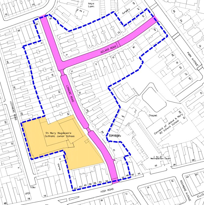
City Infinity created consultation design drawings for each scheme so residents could see what the council was proposing.
City Infinity also created 22 detailed deigns for the recommendation reports. These included the extent of the School Street scheme, signage type, enforcement camera location, operational times and the traffic orders required.
Technical drawing of detailed design of a scheme
Get in touch
Contact us if you would like us to work with you on delivering successful School Streets. Our e-mail address is info@mpsmartertravel.co.uk